Boroughs
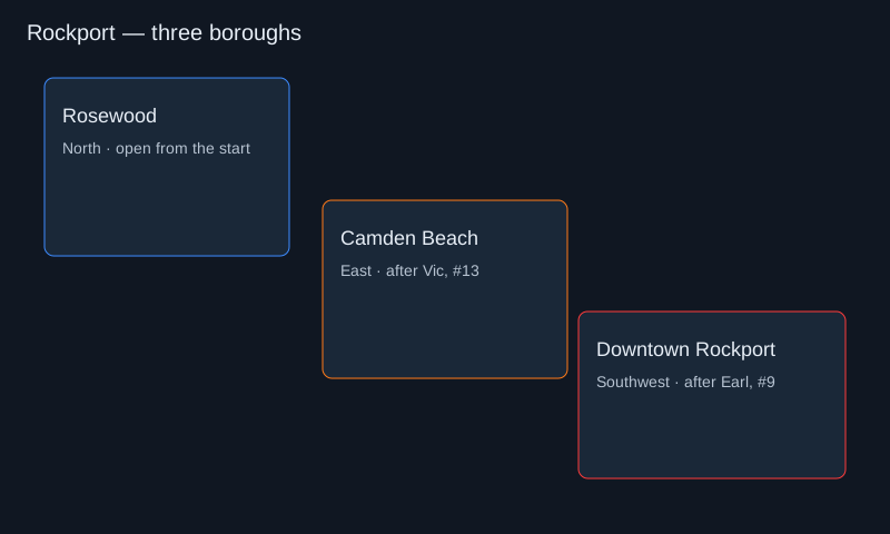
The NFS Wiki splits Rockport into Rosewood in the north, Camden Beach to the east, and Downtown Rockport to the southwest. Wikipedia describes the city's references as Rust Belt and Pacific Northwest places, including Pittsburgh, Seattle, and Portland. That is atmosphere, not a claim that one real street grid was copied.
You begin in Rosewood. The starting safehouse is in Downtown Rosewood. Beating Blacklist number 13, Victor Vasquez, opens Camden Beach and the safehouses tied to Dunwich Village and Thrilltown in the wiki's account. Beating number 9, Eugene James, called Earl, opens Downtown Rockport and the safehouse on the east side of Highway 201.
| Borough | Side | Districts named | Opens |
|---|---|---|---|
| Rosewood | North | Heritage Heights, Petersburg, Downtown Rosewood, Forest Green Country Club, Rosewood College Campus | From the start |
| Camden Beach | East | Gray Point, Point Camden, Ocean Hills | After Vic, #13 |
| Downtown Rockport | Southwest | Agostini Heights, Century Square, Riverfront Stadium, Rockport Valley Airport | After Earl, #9 |
What the drawing is
The image on this page is an original schematic: three regions and the two gates. It is not an official EA map, and it is not a screenshot with every junction. Do not use it for a tollbooth time. Use it to remember which rival opens which side of the city.
Camden Beach, in the wiki's description, does not include the ring highway or the stadium. Those landmarks sit with Downtown. If a video calls the whole coastline Downtown, the video is using the words loosely.
Reading the map without a route trace
Use the drawing for orientation, not for a lap time. The ring highway, the stadium, the airport and the college campus are the landmarks that tell you which side of Rockport you are on. The schematic keeps those relationships and drops the individual junctions.
The two gates are progress, not geography. Camden Beach opens when Vic is beaten; Downtown opens when Earl is beaten. A safehouse can sit in a district that is already open while the next gate is still locked, so do not read a locked icon as a missing road.
The map does not mark collectibles, speed cameras or bounty. It also does not replace the in-game minimap for a pursuit route. If a video shows a shortcut that is not on this drawing, the video is the better source for that turn; this page is for the borough and the gate.
NFSMWfiles on YouTube, upload date 19 August 2009. A local illustration is shown until you press Play; only then does YouTube load.
Questions
How many areas are in Rockport?
Three boroughs: Rosewood, Camden Beach, and Downtown Rockport.
How do I unlock the rest of the map?
Beat Vic to open Camden Beach. Beat Earl to open Downtown Rockport.
Is this the 2012 map?
No. The 2012 city is Fairhaven. This page is only Rockport.
Sources
Content reviewed 2026-11-03; live gameplay has not been tested. Email corrections to [email protected].
Unofficial fan guide. Not affiliated with Electronic Arts, Most Wanted Online (MWO), or NFSMW Online. Illustrations are original concept art, not game screenshots or measured maps.